Networking and Communications

The Integrated Desert Navigation and Alert System is a versatile solution designed to assist users in remote desert environments by combining navigation, location broadcasting, and emergency alerting. This system integrates a GPS module for real-time positioning, an RFID scanner for local navigation, and BLE for wireless communication with rescuers. It features an OLED display for user feedback and audio cues for guidance, all powered by a solar-charged battery for reliability. By connecting wired and wireless nodes (RFID, GPS, BLE) with network addresses and utilizing local input (RFID and sensors) and output devices (display and buzzer), the system effectively meets the requirements of design, build, and connect functionalities.

Desing File Code File
↓ Scroll down to explore the project ↓
img

The Background

The deserts of Egypt, vast and unforgiving, are integral to the country's geography, encompassing the Western Desert, the Eastern Desert, and the Sinai Peninsula. These arid landscapes are characterized by extreme temperatures, scarce water sources, and vast expanses of barren land, making navigation and survival challenging for travelers, explorers, and researchers. The Bedouins that roam the deserts of Egypt are accustomed to the environment and can tell you which plot of desert a grain of sand came from. However, for most people a device to help with navigation or can call for help during emergency would be invaluable in such environments, providing reliable navigation, real-time location tracking, and emergency communication capabilities. Whether for archaeologists, trekkers, or local guides, the device ensures safety and efficiency in navigating these remote terrains.

Nestled within the desert near Luxor lies the Hathor Temple in Deir El-Medina, a historic site dedicated to the goddess Hathor. This temple served the artisans and workers who built the tombs of the pharaohs in the nearby Valley of the Kings. Isolated in the desert, the temple exemplifies the necessity of effective navigation tools for those venturing into such areas.

I decided to turn the map of the Ptolemaic Temple of Hathor in Deir el-Medina into a Desert Navigation and Alert System.
img
img

The Works

This is a continuation of a series of me figuring out similarities between ancient Egyptian structures and modern circuit boards. However, this was done differently, due to the lack of time, I did not design it with the attempt to match each component both in terms of aesthetic and function to its architectural counterpart. Rather, I just slapped the components onto the map, this leads to different outcomes.

Digitizing the Temple - Express Version

img
img
img
  1. Obtain Map and Temple Plan: After finding the map site, find a high-resolution temple floor plan and ensure it has clear lines for vectorization.

  2. Vectorize Image: Trace the cleaned-up map in a vector tool to convert it into paths in Illustrator. Ensure the lines are crisp and save as a black-and-white PNG.

  3. Import into KiCAD, Add Components, Make Routes: In KiCAD’s PCB editor, import the PNG, adjusting scale and line thickness to match the temple's outline then make it functional.

Giving the Design Function

This PCB is designed to function as a control and sensory interface for a helicopter, incorporating various sensors and components that enable environmental monitoring and motor control. Key components include a Seeed Studio XIAO RP2040 microcontroller, which acts as the central processing unit, receiving input and controlling output signals. The board integrates sensors such as a DHT11 for humidity and temperature measurements, BMP280 for barometric pressure, and a GY-TSL2561 for light sensing, which allow the helicopter to monitor its surrounding environment. An OLED display module provides real-time data feedback. Additionally, the schematic includes LEDs for status indicators, a motor control circuit with a MOSFET (SQ2351ES), and various switches to interact with different operational modes. This configuration enables the helicopter to gather environmental data, display information, and control motor functions effectively, making it suitable for both autonomous and manual flight operations.

img
img
img
img
img
img

The schematic is clean and efficient. The ESP32S3 serves as the central hub, connecting the GPS and GSM modules through TX and RX pins, while power is distributed via the 5V and 3.3V rails. The OLED display communicates over I2C, and both the buzzer and LED are controlled through GPIO pins for alerts. Grounding and power connections are carefully routed to ensure stability.

This design delivers a lightweight, robust system that meets the practical demands of navigation and emergency communication in remote terrains. By combining reliable components and thoughtful design, the Desert Navigation and Alert System offers a critical tool for safety and survival in Egypt’s unforgiving deserts.

img

The Final Product

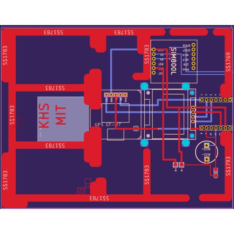
The final PCB design successfully bridges the worlds of ancient architecture and modern electronics. The traces and components are laid out in a manner that respects the original temple plan, yet the board is fully functional and could serve as an energy monitor or live-wire detector. By using the Great Temple of Abydos as inspiration, this project emphasizes the enduring importance of energy systems—whether they are social, economic, or electrical—across different epochs of human civilization.

This project, while deeply rooted in artistic expression, also serves a functional purpose, showing how ancient designs can inspire modern technology. The images included illustrate this journey from an archaeological drawing to a fully realized circuit board, reflecting the timeless connection between human innovation and energy management.

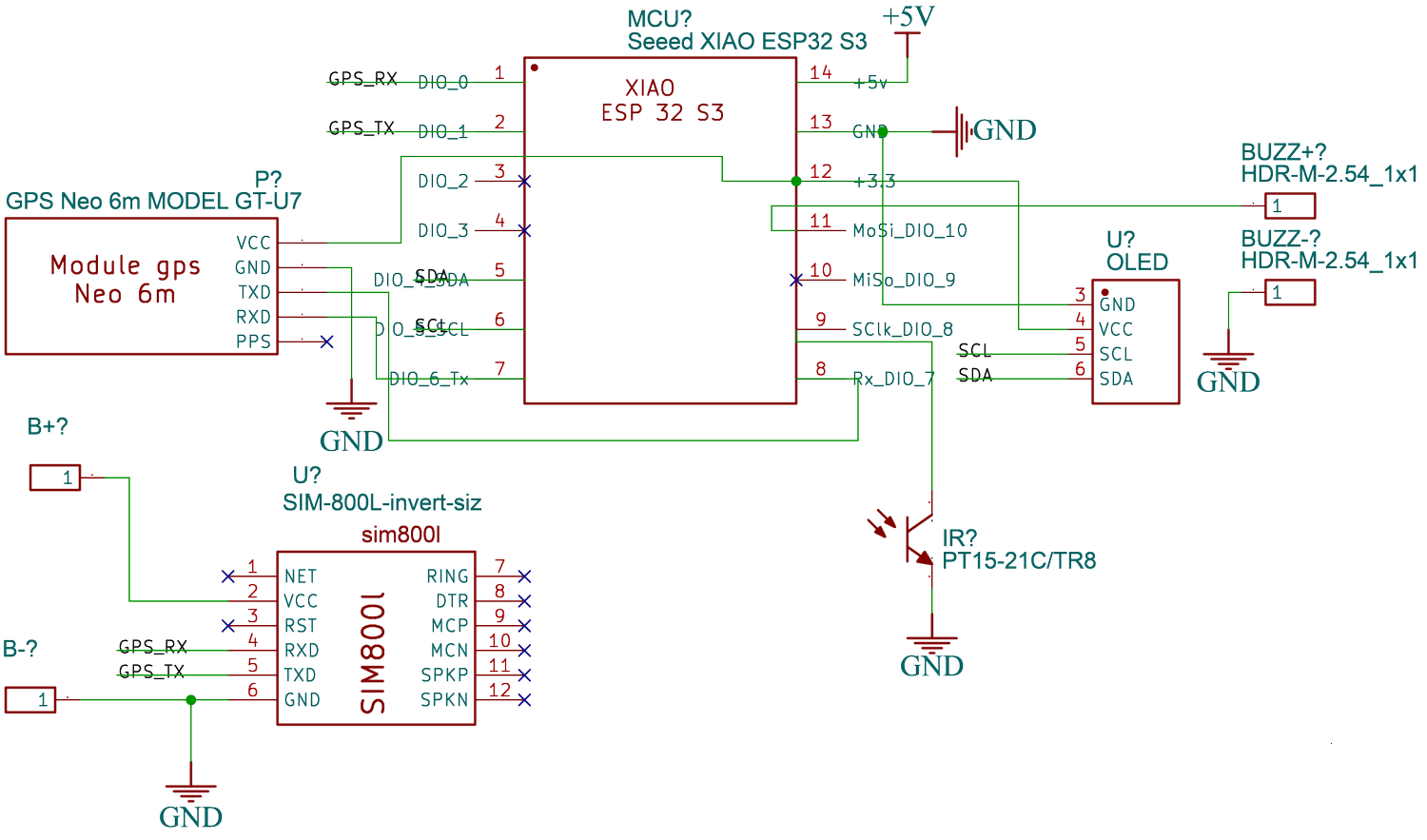
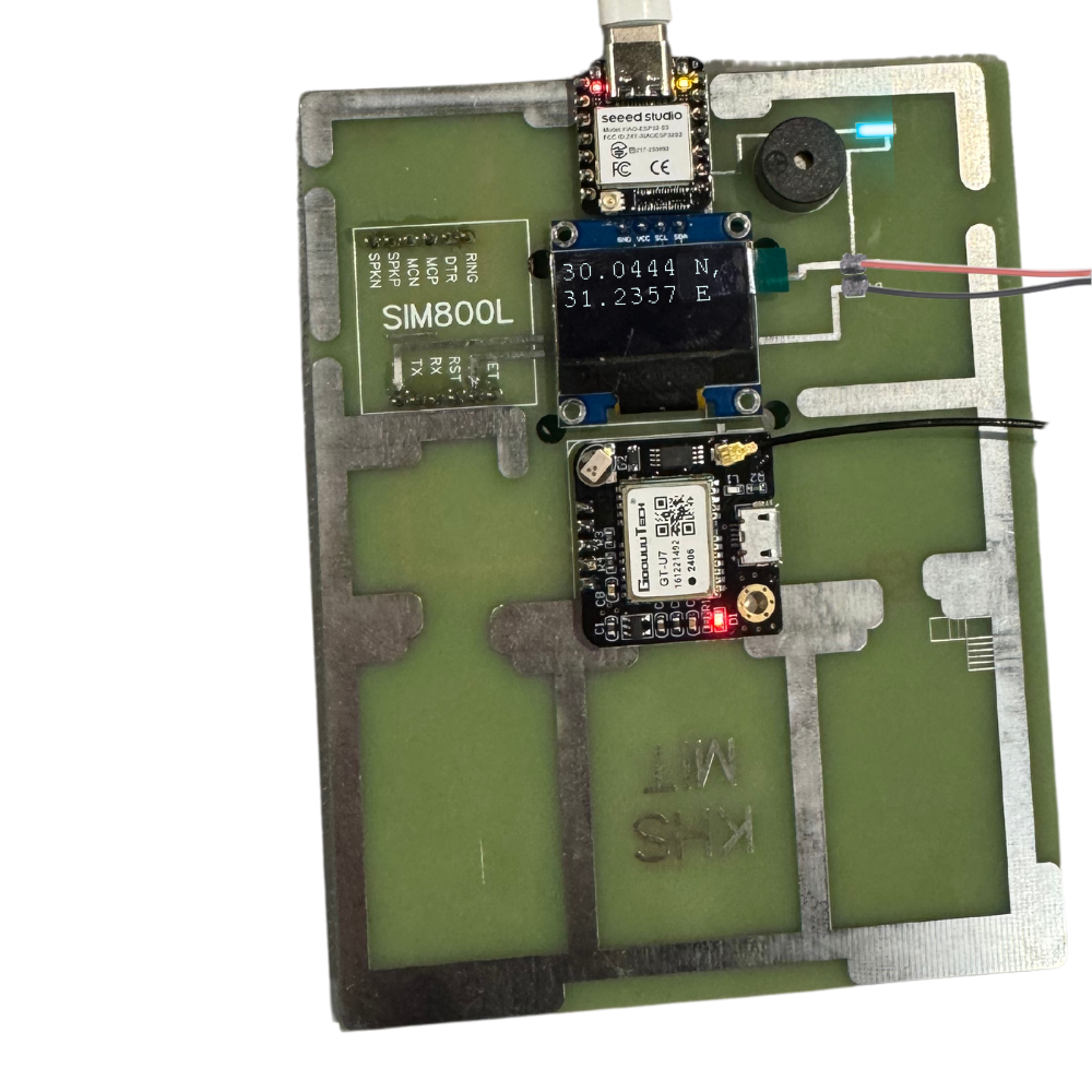
However, the design is not without its challenges. The OLED display ended up upside down, which made it impractical to enclose the board within a case as originally intended. This misalignment complicated usability and detracted slightly from the polished outcome I envisioned. Additionally, the SIM800L GPRS GSM Phone Module proved particularly tricky to operate, with its placement requiring it to be soldered onto the bottom side of the PCB. This not only made the soldering process more complex but also created logistical issues in ensuring all connections remained robust and accessible. While the board performs its intended function, these setbacks highlight opportunities for refinement in future iterations to enhance both the usability and overall efficiency of the design.

But at the end of the day, it connected to a network and it showed coordinates.

img
© 2024 Kareem H. El-Sisi, Massachusetts Institute of Technology. All rights reserved.